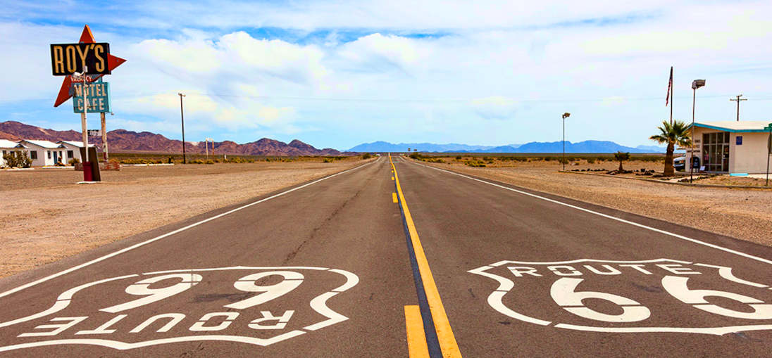
Map of historic Route 66
From Chicago to Los Angeles
About-the-USA.com
- Main
menu ►
- Life and
institutions
- Tourism & travel
- Places
★★★ About-the-USA.com ★★★
Discover Route 66 from Chicago, Illinois, to Los Angeles, California.
Which is the best direction to drive Route 66?
 Undoubtedly
from Chicago
to Los Angeles, to finish at the edge
of the Pacific in Santa Monica.
Undoubtedly
from Chicago
to Los Angeles, to finish at the edge
of the Pacific in Santa Monica.. The further you drive, the more interesting the route becomes, the more spectacular or daunting the secenry.
Scroll down to below the map for more details.
Note: Very little of Historic Route 66 is now numbered "66". For much of the journey, the historic highway, or what is left of it, runs right alongside or very close to modern interstates, and distinguishing between them on a map is often impossible. The interactive map below allows you to zoom in sufficiently to check exactly what any stretch of interstate is like, notably long stretches of I-55 and I-40.
In parts, the interstate does not follow Historic Route 66, and when the two diverge, the trace shown on the map below generally follows the historic highway (or sometimes one of the historic routes) when this is the case. When you are following part of the historic route, there are some places where it is clearly marked, others where it is not marked at all, or only once you reach an intersection, not before it, so some attention is required.
Take
care: when zooming or moving the map, do not click on
the actual route line itself, as it may disappear. To get it back,
you'll need to reload the page!
Map markers: red cities – orange: Route 66 historic sites – green: landscapes, natural heritage.
Markers are only a small selection. There are hundreds of small themed locations along the route, historic motels and garages, (some derelict), cafés, souvenir stores and old vehicle collections - some old, some new. Stop off when you want to or need to, as did people who traveled this route in the first half of the twentieth century.
Along the route...
Route 66 was officially designated as a federal highway in 1926. At the time, two thirds of the journey from Chicago to Los Angeles ould be made on unpaved roads, gravel or dirt tracks. Over the next half century, Route 66 was progressively upgraded, and here and there small changes were made. Today, along the 2278 miles of route or thereabouts, depending on which variants you take, there are obviously a lot of things to see. This page lists and mentions only some of the more interesting and significant spots on the journey. There's little point in listing all the hundreds of small mom and pop stores, old-fashioned garages, souvenir stalls and retro-looking motels that have popped upon this route - some of them back as far back as the 1920s and 1930s, others a lot later – and many of them well after historic Route 66 was decommissioned and replaced by interstates. You'll see them every few miles ... and can stop off at those that catch your eye, or provide the service you want at the moment, fuel, food or accommodation.Travel Route 66 in the way its pioneering first users did... knowing that it still is, as Woody Guthrie called it, "a mighty hard road", but that there are places and amenities at irregular intervals all along.
Historic Route 66 in five stages
1. Chicago to St. Louis - about 300 miles
Leave Chicago either on North Ogden Avenue (the historic route) or on I-55 (the easy way out of Chicago). The two join at Junction 276. After that, follow the map, or follow roadsigns for Historic Route 66.Leave I-55 at exit 241, after Joliet, and follow the old road as far as Bloomington, or else returning to I-55 where you wish, for a faster journey.
Between Joliet and Bloomington there are a number of itneresting features to see, including the Route-66 memorabilia at Pontiac find.
From Bloomington follow the historic route (not the I-55) to Springfield, once the home town of Abraham Lincoln. You can visit the Lincoln home, as well as the Lincoln museum and Presidential library. South of Springfield the old Route 66 is now Illinois Hwy 4, and just before Auburn visit the remarkable short section of the original road that was paved in brick find . This part of the journey lets you discover the wide open farmlands of the Heart of America
Return to the I-55 at Junction 33 north of St. Louis, the city being on the west bank of the Mississippi. As you cross the river, you have a clear view of the Gateway Arch find, just north of the bridge, symbolizing this city as the gateway to the West. 192 meters high, this is the world's tallest stainless steel structure, and visitors can go to the top.
2 St. Louis to Tulsa - about 400 miles
At or from St. Louis, follow signs for the I-44 West. You can then take the Interstate for the next 160 miles, leaving at Jct 161 or Jct. 169After Jct 169 the historic 66 goes through Waynesville, then south on Hwy17, then on to Hwy AB where the 17 veers left. After Gaskozark the old 66 runs beside the 44. Carry on through Lebanon and Marshfield to Springfield find, where you can rejoin the I-44 at Junction 75.
Follow the I-44 for 60 miles as far as Junction 15, for Joplin, when you'll get back on the old route. You leave Joplin on the MO-66 (Missouri Highway 66) which later becomes the KS-66 when you cross into Kansas, and continue to Baxter Springs.Before Baxter Springs, stop to visit Rainbow Bridge, built 1923, the only surviving single-span Marsh concrete arch bridge on the route.
If you remain on the I-44 after Joplin, you'll maybe want to leave at Junction 1, to Baxter Springs – unless you want to pay the toll on the Turnpikes in Oklahoma. The I-44 .through the state of Oklahoma is a toll road. Unless you are in a hurry, take the old Highway 66 through the whole state
From Baxter Springs, follow the US-69 Alt (also marked as Cycle route 66) to Miami (Ok.), and keep following the US 59, cross the Turnpike and follow the US60 through Afton and on to Vinita. From Vinita and as far as Tulsa find, you are then actually on Highway 66 . Enter Tulsa on the non-tolled I-44.
3. Tulsa to Amarillo - about 380 miles
Tulsa is the second largest city in Oklahoma, a place whose economic development in the 1920's on the back of Oklahoma's oil boom, has left it with a fine heritage of buildings from the Art Deco age, when Route 66 was born.Leave Tulsa on the I-44 but branch off it at Jct 222, signposted OK 66 West. Follow the old highway, stopping off at the Route 66 interpretive center find at Chandler. Then continue on old 66 until it joins the I-35, which you follow until the intersection with I-44 at Edmond find, on the outskirts of Oklahoma City. You may like to stop off at Edmond to visit the National Cowboy & Western Heritage Museum find, which is beside the I-44 (take exit 129 marked M-L.King Ave).
Unless you want to visit Oklahoma City, return to or continue on I-44 as far as Junction 123B where you follow OK 66 West. You're now back on old Route 66. Carry on through El Reno, just following the 66 signs. Old Route 66 now follows, and sometimes runs beside the toll-free I-40 for most of the rest of the way to L.A.
At the Cherokee Trading Post find, you can either continue on the US 281 or else join the I-40 as far as Exit 101 and turn right to rejoin the 281 at a location called Hinton... but take care, there are not many direction signs here. Make sure you remain to the north of the I-40.. on a straight single-carriageway road stretching ahead into the distance. You'll pass the carefully restored Lucille's Gas Station find, ,and while you cannot actually get gas from the 1930s pumps, this is reputedly one of the classic photo-op locations along the route.
. A sign confirms you are on the old 66 as you enter Weatherford. Take Main Street, which runs beside the I-40, then follow 54 South but leave it before it crosses under the I-40. Carry straight on, and you're on tye old 66 again, running beside the i-40. At Clinton, visit the Oklahoma Route 66 Museum find, one of the best along the route.
From Clinton, Historic Route 66 is the I-40, or right beside it. At Elk City, if you are on the I-40 leave it at Exit 41, and go into town to visit the National Route 66 and Transportation Museum. Rejoin the I-40, then leave it at Exit 26 or 25 and on as far as Texola, where you enter Texas.. The land around you here is bleak and treeless, and the road - the I-40 with two service roads (old 66 routes maybe) run straight ahead and into the distance for mile after mile.
Leave the interstate at Exit 143 to go through McLean, with its 1929 gas station, then continue on the interstate across vast expanses of flat land. Leave it again at Exit 98 to follow a historic section of Route 66, now TX 207 then 2161. This was part of the old route that turned many travelers to despair.
Route 66 and the I-40 part company at Exit 85, as you approach Amarillo., and historic 66 becomes Route 40 West, as it runs through and out of Amarillo.
4. Amarillo to Flagstaff - about 600 miles
For most of this leg of the route, Historic Highway 66 has been integrated into Interstate 40, though the Interstate skirts round the little townships that grew up along the historic route. At one such location, Adrian Texas, there's a marker indicating the midpoint on Route 66 - 1139 miles from Chicage ond another 1139 to go, to Los Angeles. There's not much else to see here, just barren semi-desert on either side of the road. As you leave Texas, at Exit 0 the old Route 66 parts company with the interstate .For ten miles the two are slightly apart, until they reconnect at St. Jon. There's little to see around here, but if it's wide open spaces you're looking for, you'll enjoy this part of the trip. You may want to leave the interstate at Exit 277 for Santa Rosa with its hotels and eateries.. Then it's back in the saddle for many more miles of wide open spaces. At exit 197,for Moriarty, the old and modern routes separate again, remaining apart as you come to the end of the vast plains and enter the hills for the rest of the way to Albuquerque. Naturally, the old route 66 runs straight through the middle of Albuquerque, past the "Old Town".. a small area with traditional adobe buildings and a town plaza that is over 300 years old.
On leaving Albuquerque, turn right onto route 345 to visit the Petroglyph National Monument, one of the oldest historic monuments in the USA, with rock carvings dating back 3000 years.
Back on the I-40, continue as far as exit 117 at Mesite, from where you'll take a section of the historic Route 66 through a rocky desert landscape. At Laguna, the old 66 becomes New Mexico Highway 124 . Beside interstate Junction 89, the 124 meets the 117, becoming the 122 after Grants. From here the old 66 and the new I-40 run side by side until junction 122 at Campbell Pass, with its Continental Divide Indian Market. Here everyone has to join the I-40, as the old 66 runs out.
You can pick the old road up again at exit 36, signed Iyanbito, continuing on to Gallup, after which it becomes the 118 as far as the end of New Mexico, and the start of Arizona. This is hot, dry country, so make sure you have water with you. At exit 311, turn off to visit the Petrified Forest, the fossilized remains of the trees that grew in this now desert area over 200 million years ago. Compared to these, the petroglyphs you maybe saw at Albuquerque are decidedly recent. The Petrified Forest is a National Park, with some stunning views and hiking trails. A few miles top the north, Arizona's Painted Desert offers some exquisite colored rock landscapes.
The I-40 / Route 66 continues across relentless scrub desert. At Exit 233 turn off to visit the spectacular Meteor Crater (visitor center and trail find) 5 miles south of the interstate. Finally, as you get closer to Winona, something new appears. Monutains on the horizon. You're looking at Humphrey's Peak, elevation 12,637 feet (3,852 m), the highest point in Arizona.
After Winona, it's just a few more miles to the center of Flagstaff As you get towards downtown, Historic Route 66 is actually marked on the sign boards.
5. Flagstaff to Los Angeles - - about 480 miles
After Flagstaff, the landscape changes. The Route 66 trail follows the I-40 through prairie and forest as far as Exit 185 for Bellemont, then continues along a narrow forest road, rejoining the interstate at junction 171. Leave at exit 166 to go through the small town of Williams. From Williams, railroad buffs will want to take an excursion on the historic Grand Canyon Railroad (see historic steam railroads), a 64 mile trip to the edge of the canyon (train trips daily - leave 9.30 in general). The alternative is to drive from Williams to the Canyon.After Williams rejoin the interstate after the town, continuing to exit 139 for Crookton. At the end of the slip road follow the sign for Historic Route 66 and continue to the town of Seligman, with its Route 66 themed stores and restaurants After Seligman, the old Historic Route 66 crossed the river on the Old Trails Bridge, used in the 1940 movie of The Grapes of Wrath, and visible to the south. Today this carries a pipeline, not vehicles.
Once in California, leave the interstate at exit 148, then on through Needles. Don't miss the turn left sign for Historic 66 at the traffic lights. You'll rejoin the interstate at junction 139. Remain on the I-40 until exit 133 to follow the old road, crossing the interstate again at junction 107 following the sign for Amboy. The old road continues on westwards until the point where it crosses the I-40 at Junction 50. The two routes then run side by side as far as the town of Barstow, where there is another route 66 museum.
The old route continues on to Victorville, where one needs to join the I-15, following it as far as exit 129 for Cajon Bvd., then back on the old road as far as San Bernardino. To all intents and purposes, your journey along historic Route 66 is at its end, or early at its end. You are in the Los Angeles urban area, and can now choose your own route through the metropolis as far as the very end of the road, where Route 66 meets the Pacific Ocean, at Santa Clara pier. From there, there's no way forward – just back, if you want to return to your departure point doing Route 66 in reverse. But maybe 2400 miles is enough for one trip, and you ultimate destination will be ten miles south of Santa Clara, Los Angeles International Airport, LAX, for a plane back to wherever you came from.
The ten miles to LAX will take you on California Highway 1.... And if you enjoy road trips, that's maybe the next one to discover.
Accommodation on Route 66
There are hundreds of places to stay along Route 66. Some can only be booked directly, many more can be booked in advance on reservation sites such as ► Booking.com or ► Hotels.com. You can't do a search on a route, so you'll need to key in the name of a location on one of these hotel search engines, and check out what's on offer.Click ► here to search key locations along Route 66 on Booking.com. We suggest checking out hotels using the "map" function provided by each hotel search engine, since in towns and cities, some hotels may be well off your route.
More information on selected cities
For more background to the USA.....
► Book / ebook A Background to modern America - people, places and events that have played a significant role in the shaping of modern America. A C1-level Advanced English reader for speakers of other languages, and anyone wanting to learn some of the background to today's USA. Twenty-two texts, with vocabulary guides and exercises.For California, discover About-California.com, a short guide for visitors.
About-the-usa.com
Home
page
A great selection at best rates
from Booking.com
:

Chicago:
Pontiac
St. Louis
Joplin
Vinita
Tulsa
Oklahoma City
Amarillo
Albuquerque
Flagstaff
Seligman
Needles
Barstow
Discover the U.S.A.
its past, its present, its future.
The people, places and events that made modern America - Elvis Presley, M-L King, J-F Kennedy, the Mississippi, Route 66 and a whole lot more....

E-book, paperback or hardback
its past, its present, its future.
The people, places and events that made modern America - Elvis Presley, M-L King, J-F Kennedy, the Mississippi, Route 66 and a whole lot more....
CLICK FOR DETAILS
E-book, paperback or hardback
Health care for visitors and tourists to the USA
People visiting the USA as a tourist, even those with US citizenship, are very strongly advised to take out a travel health insurance policy to cover their stay/s in the USA. Medical costs in the USA can be very high, and even a simple visit to a doctor can cost typically between $100 and $200, and a day in hospital may well cost over $3,000.About-the-USA.com
is
an independent guide to the USA, free of external advertising. Pages
may contain links to useful external websites, including US government
websites and other official sources, as well as
affiliate links to relevant travel service providers. A small
commission may be earned from purchases made through these
affiliate links.
Other
places, other countries...
Partner websites
Institutions, life and tourism- About France - a thematic guide to France. Over 200 pages of information for visitors and students.
- About Britain - a thematic introduction to Britain covering institutions, life and tourism
- Angleterre.org.uk - Le guide de l'Angleterre, en français
Travel and tourism
- About Quebec - Discover the French-speaking province of Canada
- About California - a thematic travel guide to California
- About-Portugal.com - Discover Portugal and its regions
- About Spain - discover the real Spain - an incomplete guide to Spain on and off the beaten track
About : About-the-usa.com is a Travel-Webs site
To contact this website please use the form provided.
Photo credits.
Top of page by James M. Phelps
Licence Creative Commons 2.0 NC