Regions of the United States
The USA can be divided in several ways
- Main
menu ►
- Life and
institutions
- Tourism & travel
- Places
About-the-USA.com
A learner's guide to discovering the United States
The United States
is a federation of 50 states plus the District of Columbia which is the
area around the federal capital, Washington D.C.A learner's guide to discovering the United States
Individual states cannot form themselves into sub-federations within the USA, and the Federal Government does not have the powers to group states into regional blocks either, meaning that the largest constitutional subdivisions of the USA are the individual states. There are no official regions.
Nevertheless, there are many good reasons for dividing the USA into smaller units that include more than just one single state. Numerous organisations, from federal agencies such as the Census Bureau, to corporations, like to divide the nation of over 300 million people into smaller more manageable sub-divisions, without drilling right down to state level. The trouble is that since there are no official regions, different organisations divide the USA up into different constituent regions, which vary in number from just two regions – east and west (of the Mississippi), to ten. Dividing the nation into regions allows the USA to be seen as coherent areas in different terms, in relation to geography, climate or history.
It is also useful to note that the average population of a US State is about 6 million people per state, making US states comparable in dempgraphic terms to European Union NUTS1 (top level) regions, such as German Länder, French Régions and smaller countries like Latvia, which have an average population of around 5 million.
The USA as four regions - Census Bureau divisions

The regions of the USA as
defined by the Census Bureau
The Census bureau also subdivides these four regions into nine divisions.
- The Northeast (in green) is made up of the six states of the New England division, (Connecticut, Maine, Massachusetts, New Hampshire, Rhode Island, and Vermont) plus a division known as Mid-Atlantic, including New York, New Jersey and Pennsylvania.
- The South region (in mauve) is made up of the eastern states south of the Ohio River - comprising the South Atlantic division (Delaware, DC, Florida, Georgia, Maryland, North and South Carolina, Virginia, and West Virginia) and the East south central division (Alabama, Kentucky, Mississippi, and Tennessee), along with four states west of the Mississippi, the West South Central division ( Arkansas, Louisiana, Oklahoma, and Texas).
- The Midwest (in yellow) is made up of the twelve great states of the American Plains, the East North Central division (Illinois, Indiana, Michigan, Ohio, and Wisconsin) and the West North Central division, made up of Iowa, Kansas, Minnesota, Missouri, Nebraska, and North and South Dakota.
- The rest make up the West (in red), consisting of the Mountain division, in and around the Rocky Mountains (comprising Arizona, Colorado, Idaho, Montana, Nevada, New Mexico, Utah, and Wyoming) and the Pacific division, made up of the four mainland states on the Pacific coast (Alaska, California, Oregon, and Washington) plus the mid-Pacific island state of Hawaii.
Hôtels
throughout the USA
A great selection at best rates
from Booking.com
:

Los
Angeles:

San Francisco
New York
Washington
Orlando
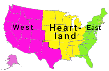
The USA as three regions
 Another recent way
of dividing the USA in economic terms uses a three region model. This
essentially defines an East
region of the USA made up of the states turned towards the Atlantic,
and a West
region composed of the Census Bureau's West region, plus
Texas.
All the rest - essentially the Mississippi basin from the Dakotas
to Alabama - is grouped together as the American Heartland.
Another recent way
of dividing the USA in economic terms uses a three region model. This
essentially defines an East
region of the USA made up of the states turned towards the Atlantic,
and a West
region composed of the Census Bureau's West region, plus
Texas.
All the rest - essentially the Mississippi basin from the Dakotas
to Alabama - is grouped together as the American Heartland.The USA as five regions

Five region map of the USA
Apart from the loss of Arizona and New Mexico, the West and Midwest regions are the same as in the Census Bureau's four region model.
For more background to the USA.....
► Book / ebook A Background to modern America - people, places and events that have played a significant role in the shaping of modern America. A C1-level Advanced English reader for speakers of other languages, and anyone wanting to learn some of the background to today's USA. Twenty-two texts, with vocabulary guides and exercises.For California, discover About-California.com, a short guide for visitors.
About-the-usa.com
Home
page
Partner websites
Institutions, life and tourism- About France - a thematic guide to France. Over 200 pages of information for visitors and students.
- About Britain - a thematic introduction to Britain covering institutions, life and tourism
- Angleterre.org.uk - Le guide de l'Angleterre, en français
Travel and tourism
- About Quebec - Discover the French-speaking province of Canada
- About California - a thematic travel guide to California
- About-Portugal.com - Discover Portugal and its regions
- About Spain - discover the real Spain - an incomplete guide to Spain on and off the beaten track
© About-the-usa.com
About : About-the-usa.com is a Travel-Webs site
To contact this website please use the form provided.

